
Assam Floods and Flood Management in India
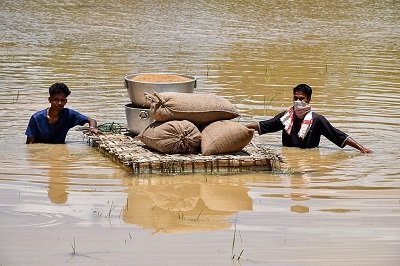
Assam has witnessed its worst floods in over 60 years, affecting over 8 lakh people and claiming more than 30 lives, highlighting persistent challenges in India’s flood management and the need for climate-resilient infrastructure.
Summary
- Floods in India are increasingly driven by a combination of climate change, ecological degradation, unplanned urbanization, and governance gaps, exposing weaknesses in flood forecasting, reservoir management, interstate coordination, and disaster preparedness.
- Building flood resilience requires integrated river basin management, scientific reservoir operations, floodplain regulation, technology-driven early warning systems, nature-based solutions, and stronger institutional coordination to shift from disaster response to disaster risk reduction.
Why is Assam Highly Prone to Floods?
- Geographical Vulnerability: Assam lies in the Brahmaputra and Barak river basins, with over 50 tributaries draining into them. Its location in the Brahmaputra floodplain makes it naturally prone to recurrent floods.
- The Brahmaputra carries one of the world’s highest sediment loads. As the river enters Assam’s plains, reduced gradient causes sediment deposition, raising riverbeds and increasing flood frequency.
- Heavy Monsoon Rainfall: Intense southwest monsoon rainfall, coupled with heavy upstream discharge from Arunachal Pradesh and Meghalaya, frequently triggers flash floods.
- Riverbank Erosion: The dynamic nature of the Brahmaputra leads to frequent channel shifts, embankment breaches, and severe erosion. About 4.27 lakh hectares of land have been eroded since 1950.
- Deforestation and soil erosion in upstream catchments increase sediment inflow, reducing river carrying capacity and aggravating floods.
- Climate Change: Increasing extreme rainfall events and higher flood peaks due to climate change are intensifying the scale and frequency of floods.
- Limited Effectiveness of Embankments: Assam has relied heavily on embankments, many of which have exceeded their design life and are ineffective against the highly dynamic Brahmaputra.
- High Flood Exposure: Nearly 39.58% of Assam’s geographical area is flood-prone, almost four times the national average, making floods an annual challenge.
What are the Causes of Floods in India?
- Flood Vulnerability in India: India has over 40 million hectares of flood-prone area out of its 329 million hectares of geographical area.
- On average, floods affect 75 lakh hectares annually, claiming around 1,600 lives, with major floods occurring more than once every five years.
- Floods are also increasingly affecting regions previously considered non-flood-prone.

Natural Causes
- Concentrated Monsoonal Rainfall: Nearly 75–80% of India’s annual rainfall occurs during the Southwest Monsoon (June–September).
- High-intensity rainfall often exceeds the carrying capacity of rivers and drainage systems, resulting in widespread flooding.
- Heavy Siltation and Riverbed Aggradation: Young Himalayan rivers such as the Ganga and Brahmaputra carry enormous sediment loads.
- Deposition of silt on riverbeds (aggradation) reduces channel capacity, increasing the frequency of overbank flooding.
- River Meandering and Course Changes: Highly sediment-laden rivers frequently alter their channels.
- For example, the Kosi River (“Sorrow of Bihar”) has repeatedly shifted its course, inundating new floodplains.
- Glacial Lake Outburst Floods (GLOFs): Accelerated glacier retreat due to climate change has expanded glacial lakes in the Himalayas, increasing the risk of sudden downstream floods, as witnessed during the 2023 Sikkim GLOF.
- Cyclones and Storm Surges: Tropical cyclones along the Bay of Bengal generate intense rainfall and storm surges that inundate coastal regions while restricting river discharge into the sea.
Anthropogenic Causes
- Deforestation and Catchment Degradation: Large-scale deforestation in the Himalayas and Western Ghats increases surface runoff, accelerates soil erosion, and raises sediment deposition in rivers.
- The ‘Embankment Trap’: India has constructed over 34,000 km of embankments since 1954.
- Excessive dependence on embankments often promotes riverbed aggradation, and breaches can result in sudden, prolonged, and more destructive floods.
- Reservoir and Dam Mismanagement: Inadequate adherence to reservoir rule curves and sudden releases during peak monsoon can aggravate downstream flooding, as observed during the Kerala floods (2018).
- Encroachment of Floodplains and Wetlands: Unregulated construction on floodplains and degradation of wetlands such as Assam’s Beels reduce the natural storage capacity of river systems, increasing flood intensity.
- Unscientific Sand Mining: Excessive sand extraction alters river morphology, destabilises riverbanks, and disrupts natural flow patterns, increasing flood vulnerability.
Urban Flooding
- Unplanned Urbanisation: Rapid concretisation has replaced permeable surfaces with asphalt and concrete, significantly increasing surface runoff.
- Loss of Urban Water Bodies: Encroachment of lakes, wetlands, and natural drainage channels has reduced cities’ flood-buffering capacity, as seen in Bengaluru and Chennai.
- Inadequate Storm-Water Drainage: Ageing drainage infrastructure, combined with blockage by solid waste and construction debris, severely restricts storm-water evacuation during extreme rainfall events.
- Climate-Induced Extreme Rainfall: Increasing instances of short-duration, high-intensity rainfall are overwhelming urban drainage systems, leading to frequent flash floods.
What Measures has India Taken for Flood Management?
- Structural Measures:
- Embankments and Drainage Works: India has constructed over 34,000 km of embankments, drainage channels, flood protection works, and raised villages to reduce flood risks.
- Dam Safety Act, 2021: Establishes an institutional framework for the surveillance, inspection, operation, and maintenance of specified dams to enhance dam safety and reduce flood risks.
- Reservoir Management: Reservoirs are operated using Rule Curves (predefined target water levels) to regulate storage, maintain flood cushions, and moderate floods during the monsoon.
- Inter-Basin Water Transfer (IBWT): The National Perspective Plan (1980) envisages linking rivers to transfer surplus floodwaters to water-deficit regions.
- Non-Structural Measures:
- Flood Plain Zoning: The Central Water Commission (CWC) circulated the Model Flood Plain Zoning Bill (1975) to regulate development in flood-prone areas and minimize flood damage.
- Flood Forecasting and Early Warning: The CWC operates a nationwide flood forecasting network using real-time telemetry, hydrological modelling, and inundation forecasting.
- Catchment Area Treatment (CAT): Afforestation, watershed management, and soil conservation measures are undertaken to reduce runoff, soil erosion, and sedimentation.
- Community-Based Disaster Preparedness: Awareness programmes, mock drills, and local disaster management plans enhance community resilience.
- Institutional and Policy Measures:
- Disaster Management Act, 2005: Provides the legal framework for disaster preparedness, mitigation, response, and recovery through the National Disaster Management Authority (NDMA), State Disaster Management Authorities (SDMAs), District Disaster Management Authorities (DDMAs), National Disaster Response Force (NDRF), and State Disaster Response Forces (SDRFs).
- Flood Management and Border Areas Programme (FMBAP): A Ministry of Jal Shakti scheme providing central assistance for flood control, anti-erosion works, drainage development, and anti-sea erosion projects.
- National Water Policy, 2012: Promotes integrated river basin management, flood moderation, watershed conservation, and restoration of natural drainage systems.
- India Meteorological Department (IMD): Provides weather forecasts and impact-based warnings to support early evacuation and disaster preparedness.
What are the Concerns Regarding India’s Flood Management?
- Constitutional and Federal Gridlock: India’s flood governance suffers from constitutional fragmentation.
- Entry 17 of the State List gives states control over water, drainage and embankments, while Entry 56 of the Union List empowers the Centre over inter-state rivers.
- This division leads to poor coordination, with upstream states often prioritizing irrigation and hydropower over downstream flood safety.
- Despite the River Boards Act, 1956, empowered River Basin Organizations have not been operationalized, preventing integrated basin-level flood management.
- Fiscal and Project Execution Failures: Performance Audits by the Comptroller and Auditor General (CAG) reveal serious weaknesses in the Flood Management Programme (FMP).
- Delays in approving Detailed Project Reports (DPRs) make project designs outdated before implementation, while the absence of basin-wide planning reduces effectiveness.
- Delayed fund releases by the Centre, diversion of funds by states and poor utilization leave many flood-control and anti-erosion projects incomplete.
- Deficient Flood Forecasting and Telemetry: India’s flood forecasting system is constrained by weak monitoring infrastructure.
- Many telemetry stations and automated water-level sensors installed by the CWC remain non-functional because of poor maintenance, lack of calibration and vandalism.
- Delayed or unreliable hydrological data limits accurate forecasting and reduces the lead time available for evacuation and reservoir management.
- Transboundary Water Governance Gaps: Flood management is further weakened by inadequate international cooperation. The Indus Waters Treaty (1960) focuses mainly on water sharing and hydropower, without addressing climate change, glacial melt or flood management.
- In the Brahmaputra basin, India depends on seasonal MoUs with China for hydrological data rather than a binding treaty, limiting transparency over upstream water releases and weakening early-warning systems in the Northeast.
- Weak Dam Safety and Reservoir Operations: Poor adherence to reservoir operation protocols often converts natural floods into man-made disasters. Reservoir operators frequently violate Rule Curves by storing excess water to maximize irrigation and hydropower benefits.
- During extreme rainfall, sudden large-scale releases from dams intensify downstream flooding. Moreover, many dams still lack legally enforced Emergency Action Plans (EAPs) and effective public warning mechanisms despite the Dam Safety Act, 2021.
- Weak Grassroots Disaster Preparedness: Disaster response at the local level remains inadequate due to limited institutional capacity.
- Many states underfund and under-equip their State Disaster Response Forces (SDRFs) and district administrations, resulting in weak community preparedness, insufficient rescue equipment and poor early-warning dissemination.
- Consequently, states remain heavily dependent on the National Disaster Response Force (NDRF) after disasters occur rather than investing in proactive local resilience.
- Concerns Related to Northeast India: The Northeast’s flood management is constrained by its fragile Himalayan ecology, transboundary river systems.
- Major rivers originate in China, Bhutan limiting India’s control over upstream water flows and data availability.
- Weak hydrological cooperation with neighbouring countries, inadequate forecasting infrastructure, difficult terrain, and poor connectivity further hinder integrated river basin management, disaster response, and long-term flood resilience, resulting in recurring loss of lives, livelihoods, biodiversity, and critical infrastructure.
What Measures Can Strengthen India’s Flood Management?
- Shift Towards Flood Resilience: Adopt the recommendations of the Rashtriya Barh Ayog (National Flood Commission), 1980, which discourage indiscriminate embankments and promote floodplain management, raised settlements, flood-resilient agriculture, and coexistence with floods.
- R. Rangachari Committee (2003) recommended a shift from flood control to flood management, emphasizing Integrated River Basin Management (IRBM), floodplain zoning, catchment area treatment, reservoir regulation, improved forecasting, and community participation.
- Improve Reservoir and Flood Forecasting: Maintain a dynamic flood cushion in reservoirs by revising Rule Curves, develop a National Water Model (NWM) and Decision Support System (DSS) for real-time forecasting, and modernize hydro-meteorological networks, as recommended by the NITI Aayog Committee on Flood Management (2021).
- Strengthen Disaster Risk Reduction: Shift from a relief-centric approach to risk reduction, investing in resilient infrastructure, preparedness, early warning systems, and the Build Back Better principle in line with the Sendai Framework for Disaster Risk Reduction (2015–2030).
- Regulate Floodplain Development: Encourage states to implement floodplain zoning laws based on the Model Flood Plain Zoning Bill (1975) through financial incentives and strict regulation of construction on floodplains, wetlands, and natural drainage channels.
- Promote Basin-Level Water Governance: Establish River Basin Organizations (RBOs) to enable integrated river basin management through coordinated planning, reservoir operations, sediment management, and interstate data sharing.
- Leverage Advanced Technology: Expand AI-based Early Warning Systems (EWS), IoT-enabled monitoring of embankments and reservoirs, satellite-based flood mapping, and strengthen the CWC National Flood Forecasting Network
- Adopt Nature-Based Solutions: Implement the ‘Room for the River’ approach and Sponge City initiatives by restoring wetlands, reconnecting floodplains, rejuvenating urban water bodies, and increasing permeable surfaces to reduce flood peaks.
- Interlinking of Rivers (ILR): It can reduce floods by storing excess monsoon water in multi-purpose reservoirs on rivers like the Kosi and Mahanadi, moderating downstream flood peaks through regulated releases.
- However, it must be complemented by floodplain zoning, embankments, and early warning systems, as it cannot eliminate floods entirely.
Conclusion
Floods in India are no longer just an annual natural anomaly—they have transformed into recurring humanitarian and economic crises aggravated by climate change and unplanned urbanization. Mitigating this vulnerability requires breaking away from short-term embankments and relief payouts. A sustainable future demands an integrated, proactive approach centered on ecological restoration, strict floodplain governance, and advanced technological forecasting.
| Mains Question:
Floods in India are increasingly becoming governance failures rather than purely natural disasters. Examine. |
Frequently Asked Questions (FAQs)
1. What is the objective of the Flood Management and Border Areas Programme (FMBAP)?
It is a Ministry of Jal Shakti scheme that provides central assistance for flood control, anti-erosion measures, drainage development, and anti-sea erosion works.
2. What is the significance of the Dam Safety Act, 2021?
It establishes an institutional framework for the surveillance, inspection, operation, and maintenance of specified dams to improve dam safety and reduce flood risks.
3. What is Flood Plain Zoning?
Flood Plain Zoning regulates development in flood-prone areas to minimize flood damage and prevent encroachment on floodplains and wetlands. It is based on the Model Flood Plain Zoning Bill (1975).
4. Why is Integrated River Basin Management (IRBM) important?
IRBM promotes coordinated planning, reservoir operations, sediment management, and data sharing across entire river basins, reducing interstate conflicts and improving flood resilience.